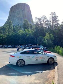
Testing self-driving cars these days is common, but VSI Labs needed to test various autonomous-vehicle (AV) applications. So, the company took its research vehicle (Fig. 1) on two unprecedented cross-country journeys. I talked with Katelyn Abel, Marketing & Communications Manager at VSI Labs, about its research and those excursions.
1. The VSI Labs research vehicle stops in the Badlands on the Drive West.
What was the purpose of the Drive West & East?
Neither drive was about proving the capabilities of VSI’s AV applications—they were strictly about discovery. More specifically, the purpose of our long-distance drives was to test the benefit of using precision lane models and enhanced positioning technology to improve the performance and safety of highway autonomous-driving applications. We were also seeking to better understand how these technologies operate across varying terrains, weather, and driving conditions.
What type of vehicle was utilized on the Drives?
VSI’s research vehicle is a 2018 Ford Fusion equipped with Dataspeed’s by-wire control system, along with numerous other AV technologies such as an Ouster LiDAR, NXP Blue Box, FLIR Thermal Camera, and more (Fig. 2). VSI engineers built a custom Linux-based computer installed inside the vehicle, which acts as a domain controller for AV functions, including the lane-keeping and adaptive-cruise-control (ACC) algorithms developed by our engineers. In the case of the Drive West & East, the vehicle also required LTE connectivity for dynamic map loading and correction services.
2. The team stops for a photo at Devil’s Tower on the Drive West.
What technologies enabled the Drive West & East?
In both projects, VSI utilized an absolute-localization system that leveraged a corrections service to attain higher accuracy positioning (Fig. 3). Absolute localization utilizes absolute position information calculated from measurement sensors such as GPS, inertial measurement units (IMUs), and the wheel odometer. To achieve a greater level of accuracy, the errors of the positioning from these fused sensors are then adjusted with data from a correction service. Correction data is used to enhance the level of precision from meter-level accuracy to the centimeter-level accuracy positioning required for some automotive applications such as ADAS and AD solutions.
3. VSI’s full stack of enabling technology is located in the trunk of its research vehicle.
Precise point positioning (PPP) and real-time kinematics (RTK) are two of the predominant correction services available today. RTK uses differential augmentation through a base station, while PPP obtains new and better information on the position and clock error of satellites.
While the Drive West focused primarily on testing the combination of HERE Technologies’ high-definition maps with RTK ground-based positioning technology from OxTS, the Drive East utilized Trimble’s PPP technology, Trimble RTX.
Combined with high-definition lane models in the HD Map, both OxTS and Trimble enabled the vehicle to know its exact position relative to the geocoded lane lines in the map, resulting in accurate lane keeping across a large geographic area.
How did the VSI team prepare for the Drives?
Because the Drive West was the first time VSI attempted a cross-country drive in AV mode, the team began preparing for this project months in advance.
VSI used two primary AV applications for the drive: ACC and HD map-based lane keeping. While our engineers had conducted extensive research and testing on these applications prior to the drives, this research was always conducted in a geofenced area, allowing the team to preemptively download and process map data. Because the Drive West & Drive East spanned over 3,000 miles of highway roads, it was necessary to develop a method of downloading and processing map data while driving.
VSI engineers wrote scripts to download the correct map data given the vehicle’s location at any given time. The script first checked to see if the file already existed, downloading the data if it had not already done so. After the new map data was downloaded, it would be processed to find a new target path for both lane keeping and ACC, and the steering command would slowly transition from the existing target path to the new path.
Another challenge the engineers encountered using HD maps over large distances was map distortion. While distortion is negligible over a small geofenced area, it can seriously disrupt lane keeping when relying on centimeter-level map accuracy.
The VSI team investigated whether this coordinate transformation was viable for driving across a large distance, learning that the transformation broke down over large distances due to the earth’s curvature. After researching alternate coordinate systems, they proceeded with the Universal Transverse Mercator (UTM) coordinate system, which breaks the earth into 6-degree longitudinal sections and gives coordinates in meters.
Preparing for the Automated Drive East project involved much of the same setup as the Drive West, as the same algorithms were used to handle dynamic map loading and map distortion. One of the critical differences was the setup of the Trimble’s BX992 hardware module. Integration of all GNSS devices generally require a few common steps, those being integration of hardware into the vehicle, integration of corrections into the GNSS hardware, and finally integration of the localized position into our vehicle’s autonomous-driving software.
What discoveries were made on the Drive West & East?
Overall, the HD-map-based lane-keeping and ACC applications worked well throughout both drives (Fig. 4). The team observed that the HD-map-based system performed adequately even when lane markings on the highways were not good for much of the drive, which would have made a vision-based system inadequate for sustained lane keeping.
4. View from the passenger’s seat during day 2 of the Automated Drive East.
There were many scenarios in which automated features could not be enabled, such as winding roads, high roadways without guardrails, areas with pedestrian traffic, and late-night/low-visibility environments. In addition, the system had to be disengaged in areas like highway exits, construction zones, newly constructed roadways, and areas with limited connectivity.
On both drives, the radar in the front of the vehicle used for ACC accumulated a great deal of dust and debris along the drive. While the radar’s performance was unaffected, other external sensors such as a camera and/or LiDAR would likely be affected by this. Accordingly, sensor cleaning will be a critical factor in the future for autonomous vehicles driving long distances.
Keeping the AV computers cool when running in warm conditions also posed a challenge, particularly on the Drive West. To combat this, VSI installed fans to cycle cool cabin air into the trunk where most of the AV gear is located. Cooling mechanisms will likely be necessary to maintain proper operating temperatures for autonomous vehicles in the future.
Lastly, both drives reaffirmed the importance of safety driving when testing on public roads. The safety driver must always be alert and thoroughly understand how to use the system. Safety driving is more mentally taxing than regular driving, as the driver must constantly anticipate what might happen next. During both trips, it was important to take breaks from driving every few hours.
What’s Next for VSI Labs?
VSI routinely travels hundreds of highway miles when transporting the vehicle to events and conferences in the U.S. In fact, driving the vehicle to those destinations is preferred over shipping, as this enables VSI to test a variety of applications and new components. One can stay up-to-date with VSI by visiting our website, or following along on LinkedIn.
Katelyn Abel is the Marketing & Communications Manager at VSI Labs, a research and advisory company on active safety and automated driving. In her role at VSI, Katelyn leads all branding, communications, and outreach initiatives. Prior to joining VSI, Katelyn held marketing roles in the financial and pharmaceutical industries.
About the Author
William G. Wong
Senior Content Director - Electronic Design and Microwaves & RF
I am Editor of Electronic Design focusing on embedded, software, and systems. As Senior Content Director, I also manage Microwaves & RF and I work with a great team of editors to provide engineers, programmers, developers and technical managers with interesting and useful articles and videos on a regular basis. Check out our free newsletters to see the latest content.
You can send press releases for new products for possible coverage on the website. I am also interested in receiving contributed articles for publishing on our website. Use our template and send to me along with a signed release form.
Check out my blog, AltEmbedded on Electronic Design, as well as his latest articles on this site that are listed below.
You can visit my social media via these links:
- AltEmbedded on Electronic Design
- Bill Wong on Facebook
- @AltEmbedded on Twitter
- Bill Wong on LinkedIn
I earned a Bachelor of Electrical Engineering at the Georgia Institute of Technology and a Masters in Computer Science from Rutgers University. I still do a bit of programming using everything from C and C++ to Rust and Ada/SPARK. I do a bit of PHP programming for Drupal websites. I have posted a few Drupal modules.
I still get a hand on software and electronic hardware. Some of this can be found on our Kit Close-Up video series. You can also see me on many of our TechXchange Talk videos. I am interested in a range of projects from robotics to artificial intelligence.


