Discovering the “Lake of Fire” with Custom Technology
What you’ll learn:
- How the Lake of Fire was/wasn’t discovered.
- The technology developed for this industry.
- How Dr. Emma Nicholson and expert climber Carla Pérez achieved the impossible on Mt. Michael.
Spoiler alert beyond here. If you want to see how a team of scientists approach hazardous conditions on a mission to possibly discover a volcanic wonder, then watch the show "Explorer: Lake of Fire," airing today, October 26th (National Geographic on Disney+). Check out the trailer:
Personally, I found it inspiring. I get a big kick out of seeing scientists achieve amazing results in these types of shows. This was no exception, well worth the watch.
As I said, spoilers ahead.
It's hard not to feel like I took a wrong turn in my engineering career after watching the triumph that is "Lake of Fire." Dr. Emma Nicholson, a volcanologist, yes… a volcanologist… and her partners climbed the summit of a mountain no human ever set foot on, survived horrendous weather, grabbed the data, and discovered the eighth "Lake of Fire" volcano in the world. Can you imagine being an explorer and discovering something new on this planet in this day and age? They did.
What is a Lake of Fire?
A Lake of Fire volcano is just how it sounds—a volcano with a consistent lake of lava bubbling to the surface. Also known as an open-vent volcano. There were only seven of these locations in the world until this expedition. Based on their depictions in movies, you'd think these Lakes of Fire would be everywhere. But they are, in fact, quite rare. They’re the only places where scientists/researchers (volcanologists) can get an insight into the inner workings and behaviors of volcanoes.
The focus of this trip was Mount Michael. It was first discovered in 2001 using satellite images and in 2017-18, showing temperatures consistent with an open-vent volcano. Dr. Emma Nicholson mentioned they tried to make this expedition in 2020 but faced huge unforeseen difficulties.
As the show begins, you see a montage of surprisingly recent eruptions and how they impact their surroundings. It becomes apparent that understanding or predicting when such events will take place is essential. Just remind yourself if one of these "supervolcanoes" erupts, it'll throw the world on end. It behooves us to see the signs and make the predictions so we can survive physically and economically.
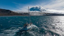
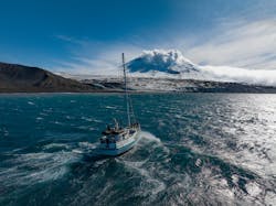
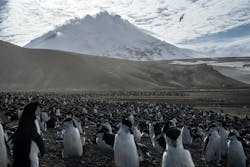
The group of researchers arrived at Saunders Island—in the South Sandwich Islands in the South Atlantic Ocean. To see just how remote it is, check out that link.
Heading Up Mount Michael
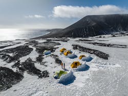
This leads the group's expert climber, Carla Pérez, to take them up to Mt. Michael’s summit. It was, indeed, a first ascent. Every climber's goal is to be the first. Pérez mentions that the group had to first lug about 3000 kg (6613 lb.) about halfway up the mountain. Most of it was gear that would keep everyone alive. Only 20% was actual scientific equipment.
Dr. Emma Nicholson elaborated on what happened when they first arrived. "So, the day that we arrived and we're setting up basecamp straight away, we flew some of the smaller drones with the thermal camera. And that was one of the few days where we were actually able to do that. So, a lot of the thermal imagery that we've collected and are using to create kind of thermal topographic models of the crater and get dimensions of the lake, etc., are from those initial flights on the very first day."
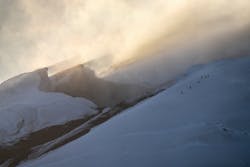
Weather prevented the team from making it to the summit on the first try. But predictive weather models showed exactly a two-hour window of calmer weather on a future day. It was spot on. They made it to the summit and volcanic rim. This model shows exactly why predicting an eruption is important. Weather placed them exactly where they needed to be and when.
They planted a seismometer along the way up. Dr. Emma Nicholson mentioned that they not only captured local volcanic vibrations, but also measured earthquakes from the Solomon Islands on the other side of the globe.
Customized Sensors
In the end, they couldn't get close enough to the edge of the volcano's crater to get gas samples, nor get a visual confirmation that the Lake of Fire was in fact there. Luckily, the drone was outfitted with miniaturized gas sensors designed by Dr. Nicholson and her colleagues along with a regular video camera. I asked for more details about the sensors they used.
Dr. Nicholson replied, "We used several different custom instruments. The gas-sensing unit (the “multigas”) and ultraviolet camera are both built with our partners at the University of Palermo, using commercial sensor components (for CO2, SO2, H2, and H2S) together with in-house designed electronics and software. The first prototypes were deployed two decades ago and they're still developing. They are installed as permanent monitoring equipment on many of the world's volcanoes, such as Etna and Stromboli in Italy.
“Since 2017, I've been working with that team to miniaturize the sensor unit to fly on drones. The main challenge that we needed to overcome was radio interference from the drone communications, which created noise on the sensor outputs. This is a particular problem when working at low gas concentrations near the limit of detection.
"For this expedition, we also deployed a new prototype system for capturing physical samples of volcanic gas, which we could then bring back to the lab. This has now been refined based on how it performed in the South Sandwich, and we recently took the revised system to the Etna volcano in Italy for further fieldwork."
Flying the drone from the edge of the crater, they were able to capture all of the gas and gas pressure data they needed… and the ever-important image of the Lake of Fire. It was no longer theoretical, assumption, or possibility. Mt. Michael was indeed a Lake of Fire, aka an open-vent volcano.
I asked Dr. Emma Nicholson and Carla Pérez, “Are you all planning on heading back to Mt. Michael any time soon?”
Dr. Nicholson: "From the technological side, I mean, we learned a lot on this expedition about how we need to make our instruments more robust to withstand some of the conditions. So, from my side, if I got another opportunity to go back, my aim would be to set up some permanent monitoring stations on the consent data backed by satellites. So actually, that we can have one of these long-time series of monitoring data like Etna or Stromboli, some of those volcanoes where we really learn a heap about how volcanoes behave. So, a lot of work is going on behind the scenes now. Like how can we make our sensors able to withstand those conditions, it can win. If that opportunity comes up, we're ready to deploy."
Carla Pérez: "I would love to go and help Emma go to any other crazy place on volcanos to explore. I would love to just be part of the next expedition."
About the Author

Cabe Atwell
Technology Editor, Electronic Design
Cabe is a Technology Editor for Electronic Design.
Engineer, Machinist, Cartoonist, Maker, Writer. A graduate Electrical Engineer actively plying his expertise in the industry and at his company, Gunhead. When not designing/building, he creates a steady torrent of projects and content in the media world. Many of his projects and articles are online at element14 & SolidSmack, industry-focused work at EETimes & EDN, and offbeat articles at Make Magazine. Currently, you can find him hosting webinars and contributing to Electronic Design and Machine Design.
Cabe is an electrical engineer, design consultant and author with 25 years’ experience. His most recent book is “Essential 555 IC: Design, Configure, and Create Clever Circuits”
Cabe writes the Engineering Life & Engineering on Friday blog on Electronic Design.
See Cabe's cartoons & comic strips here.
Comment About the Article
To join the conversation, and become an exclusive member of Electronic Design, create an account today!

Leaders relevant to this article: