Airborne Electromagnetic Survey Offers Birdseye View of Geographic Details
What you'll learn:
- What is airborne electromagnetic surveying and what are its applications?
- What is the level of safety when performing a survey?
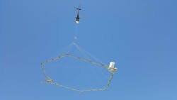
You may have seen one before, a helicopter or light aircraft towing a giant circular rig, and wondered what that strange contraption is and what it’s used for. To assuage those who may think it's a nefarious government entity conducting classified experiments, it actually has a more mundane explanation. The giant circular rig is loaded with sensors and used for airborne electromagnetic surveys (AEMs) carried out by the United States Geological Survey (USGS) and state agencies to map geological formations and other tomography or subsurface applications.
The history of AEMs can be traced back to WWII, when they were used to track submarines—the magnetic anomaly detector was attached to aircraft. The military still uses it today. The sensor system can be used for a myriad of different applications, including gathering data on bedrock below surface water, such as aquifers, magma detection, seismic activity, petroleum and mineral exploration. While the technology has advanced over the years, conducting those surveys has remained relatively unchanged.
How Airborne Electromagnetic Surveys Are Conducted
Although AEMs are conducted using different sensor-oriented rigs, the method varies and can be modified depending on the topographical or subsurface application. In general, electroconductivity is measured using a helicopter or light aircraft (think Cessna) outfitted with a wire loop outfitted with sensors and other instruments, which is suspended below or behind the aircraft. Those sensor-packed loops are flown at a height of about 100 feet or more above the surface of the ground, water, or open volcano. The sensor hoop transmits weak low-frequency radio waves into the surface, which can penetrate more than 1,000 feet deep, then measures the RF response that bounces back.
The surveys are carried out along preplanned flight paths that resemble those from mowing lawns, traversing back and forth until complete coverage is attained. The collected data is then processed to produce a 3D image created from multiple slices, similar to some 3D printing methods. The image provides scientists with a detailed model of ground or subsurface areas.
How It Works
Magnetometer sensors placed on the large wire hoop record the intensity of the magnetic field at the sensor, which is a combination of the field produced by the earth, solar winds, and even the magnetic field produced by the aircraft. By filtering out those variations, the resulting aeromagnetic map shows the desired features that were being mapped.
For example, filtering out specific magnetic noise will produce the spatial distribution of certain minerals found in the upper crust of the earth's surface. Conductivity underground filters out certain minerals, such as iron oxide or magnetite. It can also be helpful when trying to locate other minerals or even subsurface bodies of fresh water, along with their quality.
The USGS regularly outsources its AEM surveys to companies specializing in the field craft, including SkyTem (see figure), which provides varying levels of sensor packages depending on the application. For instance, the SkyTEM306 HP is designed for near-surface and deep exploration. It features magnetic sensors with a dipole moment of ~500,000 NIA and operates at speeds of up to 150 km/h with a transmitter and receiver terrain clearance of 50 meters. Others are rigged for high-resolution near-surface applications, while others are designed for deep-surface detection.

In addition, some have taken to outfitting drones with AEM packages, which have proven useful for mineral exploration and detecting unexploded ordinance. They've been an invaluable tool for prospective construction sites, too, where bedrock, sediment and other surface materials can help determine foundation and infrastructure types without digging or taking soil samples.
Safety Concerns?
Some may wonder if the technology is safe to use with humans in the area, which is understandable considering they've never seen a giant hoop being dangled below an aircraft. According to the USGS, the electromagnetic signals generated by the sensors are weaker than those produced by natural and manmade sources.
Operations are handled by qualified people who specialize in surveying, and the aircraft is high enough so that there's no rotor wash (or winds generated by aircraft) felt on the ground. The sensor packages are also secured to the aircraft using stainless-steel cabling and Kevlar safety rope, and the aircraft fly high enough for obstacle and power-line avoidance.
AEMs provide many benefits to both the public and scientists with the primary being nonevasive. Scanning for surface and subsurface areas doesn’t require digging or the removal of local wildlife or native plant species. The area isn’t impacted in any way, although the sound of aircraft may alarm animals. They also promote public health by identifying water quality and protecting aquafiers by the state performing the survey.
What’s more, AEMs offer a better understanding of below ground activity, which provides farmers detailed information about the soil and minerals in the area. So, while that giant hoop may look intimidating, it’s anything but.
About the Author

Cabe Atwell
Technology Editor, Electronic Design
Cabe is a Technology Editor for Electronic Design.
Engineer, Machinist, Cartoonist, Maker, Writer. A graduate Electrical Engineer actively plying his expertise in the industry and at his company, Gunhead. When not designing/building, he creates a steady torrent of projects and content in the media world. Many of his projects and articles are online at element14 & SolidSmack, industry-focused work at EETimes & EDN, and offbeat articles at Make Magazine. Currently, you can find him hosting webinars and contributing to Electronic Design and Machine Design.
Cabe is an electrical engineer, design consultant and author with 25 years’ experience. His most recent book is “Essential 555 IC: Design, Configure, and Create Clever Circuits”
Cabe writes the Engineering on Friday blog on Electronic Design.
See Cabe's cartoons & comic strips here.
Comment About the Article
To join the conversation, and become an exclusive member of Electronic Design, create an account today!

Leaders relevant to this article: