How the U.S. Military Helped Shape Modern Tornado Forecasting
What you'll learn:
- Insight into how early tornado weather forecasts were established.
- How radar was used to track tornadoes.
- How bureaucracy prevented the release of tornado forecasts and warnings.
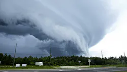
During his late shift working at Tinker Air Force Base’s Air Weather Service station in 1948, Captain Robert C. Miller was tasked as a weather forecaster to analyze U.S. Weather Bureau surface maps and upper-air charts for atmospheric instability. This was done to predict thunderstorm activity, which can hamper flight operations.
It didn’t take long for a storm to develop, and soon after at 9:30 PM, a tornado was spotted heading Northeast from Oklahoma City. By 10:00 PM, the tornado hit the Air Force base, causing extensive damage to buildings and planes and injuring eight servicemembers. This was Round One.
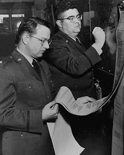
Round Two happened a week later on March 25, 1948, when a tornado touched down just 100 yards from the previous tornado’s path, damaging 84 planes, hangars, and other buildings. Three days after the original tornado wreaked havoc, Miller and Major Ernest Fawbush (Fig. 1) were tasked with developing methods of tornado forecasting. The pair studied reports and charts from previous tornado events to devise what atmospheric conditions were favorable in producing tornadic activity with some degree of accuracy.
While military radar was being adapted for forecasting use, producing an outline of tornadoes, it couldn’t show what was happening internally or rotation. As a result, forecasters could see the outlines of storms but not their internal features such as rotation. Miller and Fawbush's findings on atmospheric phenomenon present in past outbreaks were a big help in their initial forecast, as the pair found that the same conditions from the March 20 tornado were present on the 25th. They also found that the highest risk for tornadic activity in central Oklahoma was late afternoon into the evening.
Tinker base commander Gen. Fred Borum used Miller and Fawbush’s initial findings to create a severe weather safety plan for base personnel. He asked the pair if they could create a tornado warning plan based on that information, which they were reluctant to do, as the science wasn’t accurate enough. They did it anyway, and sure enough, storms out of Texas helped drive the tornado that touched down on March 25.
The pair also distributed their tornado forecasts to the American Red Cross and Oklahoma Highway Patrol. However, government bureaucracy would prohibit the use of the word “tornado” in their warnings as they felt it would incite panic among the public. “Severe Local Storms” was the alternative, and consequently, tornado-related deaths increased during the 1950s.
Radar Research Leads to More Sophisticated Forecasts
Technology at the time was limited and hadn’t progressed much beyond traditional weather forecasting using weather balloons, barometers, thermometers and the like. Radar was still in its infancy in the 1940s, but by 1948, researchers from the University of Illinois (Fig. 2) were using it to detect rainstorm locations and movement patterns.
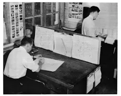
The research team got their hands on used military radar equipment from a surplus dealer and installed it onto the roof of a Pfister factory building in El Paso, Illinois. They coupled that with a 200-square-mile network of 51 rain gauges and observations from locals to create an effective basis for an accurate weather warning system.
“With radar, rainstorms can be kept under observation for several hours. This makes possible a warning system, by which, someday, radar will serve our everyday needs,” stated the researchers in their 1949 report “Weather and Rainfall.”
It wasn’t until 1952 that the first experimental public tornado forecast was issued by the U.S. Weather Bureau, which proved inaccurate. It was successful the following evening, though, when a string of tornadoes broke out across several states within Tornado Alley.
While the Weather Bureau would eventually lift the ban on issuing tornado warnings, the FCC would keep it in place for all media outlets (television and radio) until 1954, when meteorologist Harry Volkman broadcast the first televised tornado warning over WKY-TV (now KFOR-TV) in Oklahoma City. Volkman believed that banning warnings cost lives and decided to interrupt programming to warn Oklahoma City viewers of the approaching funnel.
As one could imagine, the FCC and station chief were displeased with Volkman’s action. However, the station was flooded with phone calls and letters thanking the meteorologist for his actions.
About the Author
 Cabe Atwell
Cabe Atwell
Technology Editor, Electronic Design
Cabe is a Technology Editor for Electronic Design.
Engineer, Machinist, Cartoonist, Maker, Writer. A graduate Electrical Engineer actively plying his expertise in the industry and at his company, Gunhead. When not designing/building, he creates a steady torrent of projects and content in the media world. Many of his projects and articles are online at element14 & SolidSmack, industry-focused work at EETimes & EDN, and offbeat articles at Make Magazine. Currently, you can find him hosting webinars and contributing to Electronic Design and Machine Design.
Cabe is an electrical engineer, design consultant and author with 25 years’ experience. His most recent book is “Essential 555 IC: Design, Configure, and Create Clever Circuits”
Cabe writes the Engineering Life & Engineering on Friday blog on Electronic Design.
See Cabe's cartoons & comic strips here.
Comment About the Article
To join the conversation, and become an exclusive member of Electronic Design, create an account today!
 Leaders Logo
Leaders relevant to this article: