Precise and accurate positioning and navigation functionality is an imperative in today’s advanced systems. When it comes to inertial navigation solutions, most legacy approaches rely on extensive post-processing to reach the required high levels of precision. To achieve highly accurate mapping and observability, such post-processing workflows increase development costs due to the needed time and labor involved.
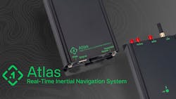
Addressing this issue, Point One Navigation introduced the Atlas Inertial Navigation System, which offers both accuracy and affordability to autonomous vehicles, mapping, and other applications. Designed for deployment in large fleets, it integrates a highly accurate, low-cost GNSS receiver and inertial measurement unit (IMU) with the Polaris RTK corrections network and sensor-fusion algorithms. The resulting affordability eases difficulties to entry and allows for companies to equip their entire autonomous fleet in a cost-effective manner.
Features include an easy-to-use user interface, on-device data storage, Ethernet, and Wi-Fi. It can be configured and operated using smartphones, tablets, and in-car displays. Addressing sectors that include automotive, autonomous vehicles, robotics, mapping, and photogrammetry, Atlas’ real-time capabilities and affordability will enable fleet-level deployments of ground truth-level location functionality.