GPS-Free MagNav is Immune to Spoofing and Jamming
What you'll learn:
- How does MagNav stack up against GPS?
- Results of a test flight involving aircraft with the MagNav platform.
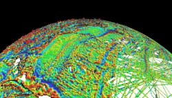
Magnetic Navigation (MagNav) is a highly resilient and accurate alternative to GPS, using the Earth’s magnetic field to determine absolute position. In electronic warfare (EW), GPS’s vulnerabilities can be exploited at both the tactical and satellite infrastructure levels.
The Defense Innovations Unit (DIU) solves operational problems identified by the armed forces and integrates them into the U.S. Department of War's innovation strategy. Its latest quantum sensing achievement shows aircraft can safely and accurately navigate vast stretches of ocean without relying on the same GPS that millions of civilians use to move through traffic.
MagNav, DIU's magnetic navigation program, was launched in spring 2024 under the name "Transition of Quantum Sensing." A total of 72 companies submitted applications to the commercial solutions opening, with Honeywell Aerospace selected to move forward with prototype development.
Leveraging Quantum Sensors
MagNav systems use quantum sensors to read the Earth's natural magnetic field. They turn the planet's crust into an invisible, unjammable map that allows pilots to navigate safely regardless of weather, time of day, or GPS availability.
Onboard software compares real-time sensor readings against pre-existing, geo-referenced magnetic anomaly maps (like the World Magnetic Model) to pinpoint absolute position.
"This is a significant win for the department's quantum sensing priorities, showcasing that MagNav capabilities are no longer a distant research goal," said Kyle Norman, deputy director of DIU's Kill Web portfolio. "We moved from problem sourcing to solicitation to prototype in a matter of months."
Because it reads ambient natural fields rather than emitting or receiving radio waves, it cannot be jammed, spoofed, or electronically detected. The new technology also significantly improves on legacy backup options, such as radar mapping or visual cues like rivers, highways, and cities.
MagNav Test Flight
The system was installed aboard an Embraer 170 aircraft (see figure) to demonstrate real-world capabilities. The aircraft flew over 4 hours and 23 minutes across the open Pacific Ocean from Washington state's Puget Sound to southern Alaska and back without any GPS input.

The MagNav system was said to improve position accuracy by 89% compared to traditional backup navigation methods. The navigation data streamed directly to the pilots in real-time via standard tablets, showing that military personnel can field the technology without a massive overhaul of cockpit instruments.
The test mission also added the complexity of the ocean surface — a featureless, constantly shifting expanse that would traditionally require internal sensors in the absence of GPS.
The problem is that classical sensors drift over time. What starts as a small miscalculation can become a massive, dangerous deviation if left unchecked. By reading the Earth's magnetic signatures, MagNav gives pilots a highly accurate, continuous map even when no visible landmarks exist.
Honeywell and DIU are preparing to demonstrate the technology on a U.S. military C-17 Globemaster III cargo aircraft later this year. By proving that aircraft can maintain pinpoint accuracy over the featureless ocean without GPS, the War Department is taking a significant step toward ensuring that military and commercial pilots can safely reach their destinations, no matter what happens to the satellite networks above them.
About the Author
Murray Slovick
Contributing Editor
Comment About the Article
To join the conversation, and become an exclusive member of Electronic Design, create an account today!
 Leaders Logo
Leaders relevant to this article: