Drone Takes Ozone Measurements Over Mt. Qomolangma
What you’ll learn:
- How scientists measured ozone at altitudes reaching 8,861 meters.
- How glacier winds move ozone downward through the atmosphere.
- How drones can help researchers collect data in harsh environments.
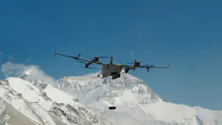
A team of scientists from Peking University (PKU) and the Chinese Academy of Sciences managed to successfully measure ozone over the Mount Qomolangma area after collecting vertical ozone distribution data from the ground all the way up to 8,861 meters. What’s more, they also captured the process of ozone being transported downward by glacier winds, gaining valuable insight into how ozone moves through the atmosphere over the Qinghai-Tibet Plateau.
Ozone is extremely important for the planet, as the gas molecule made up of three oxygen atoms acts as a protective shield against UV light high up in the atmosphere. It’s not very friendly at ground level, however, as it becomes harmful when formed from vehicle exhaust, power plants, and factory pollutants after reacting with UV light. It forms the smog some cities experience daily, causing a host of breathing problems and other health issues.
Ozone also acts as an important indicator of atmospheric environmental changes. On that front, the Qinghai-Tibet Plateau provides researchers with a unique place to study those changes because it has a relatively clean atmospheric background.
Scientists previously observed that glacier winds can transport ozone from higher altitudes in the atmosphere down toward the Earth's surface. But they didn't have enough direct measurements to understand the full process or determine the amount of ozone they can carry. Part of the problem is the extreme environment around Mount Qomolangma, as the high elevation makes it difficult to use conventional aircraft and other equipment to collect measurements at different altitudes.
Modified Drone to Handle the Environment
To get around those challenges, the scientists partnered with DJI to modify a vertical takeoff and landing fixed-wing hybrid drone to conduct their research. The aircraft combines the ability of a multi-rotor drone to take off and land vertically with the efficiency of a fixed-wing aircraft during forward flight. Think of it like an Osprey, which can hover like a helicopter and transition to forward flight. This combination allowed the team to operate the aircraft in an environment where traditional drones would have difficulty maintaining flight.
With the new drone in hand, the scientists conducted 12 days of field operations on the northern slope of Mount Qomolangma and completed 32 flight sorties. During those flights, the drone passed the 8,848-meter elevation mark twice, with one flight reaching a stable altitude of 8,861 meters while carrying a scientific payload.
The altitude wasn’t the main achievement of the endeavor, though. Rather, it was taking successful atmospheric measurements through a large vertical section of the atmosphere, giving them a better look at how ozone concentrations change with altitude. Moreover, the measurements allowed the team to observe the downward movement of ozone caused by glacier winds.
Final Thoughts
The breakthrough could give scientists a better understanding of atmospheric environmental changes across the Qinghai-Tibet Plateau. It may also provide evidence that can be used to study the relationship between glacier winds and ozone transport, something that has been difficult to measure directly. Moreover, it could open the door for atmospheric research in other difficult environments.
As drones become better at carrying scientific instruments and operating in harsh environments, they may give scientists another way to collect detailed measurements from places that are difficult, expensive, or dangerous for people and conventional aircraft to reach.
About the Author
 Cabe Atwell
Cabe Atwell
Technology Editor, Electronic Design
Cabe is a Technology Editor for Electronic Design.
Engineer, Machinist, Cartoonist, Maker, Writer. A graduate Electrical Engineer actively plying his expertise in the industry and at his company, Gunhead. When not designing/building, he creates a steady torrent of projects and content in the media world. Many of his projects and articles are online at element14 & SolidSmack, industry-focused work at EETimes & EDN, and offbeat articles at Make Magazine. Currently, you can find him hosting webinars and contributing to Electronic Design and Machine Design.
Cabe is an electrical engineer, design consultant and author with 25 years’ experience. His most recent book is “Essential 555 IC: Design, Configure, and Create Clever Circuits”
Cabe writes the Engineering Life & Engineering on Friday blog on Electronic Design.
See Cabe's cartoons & comic strips here.
Comment About the Article
To join the conversation, and become an exclusive member of Electronic Design, create an account today!
 Leaders Logo
Leaders relevant to this article: